abigailbrady: (leicester)
no really, I have

Seem to have discovered twitter. Username same as here.

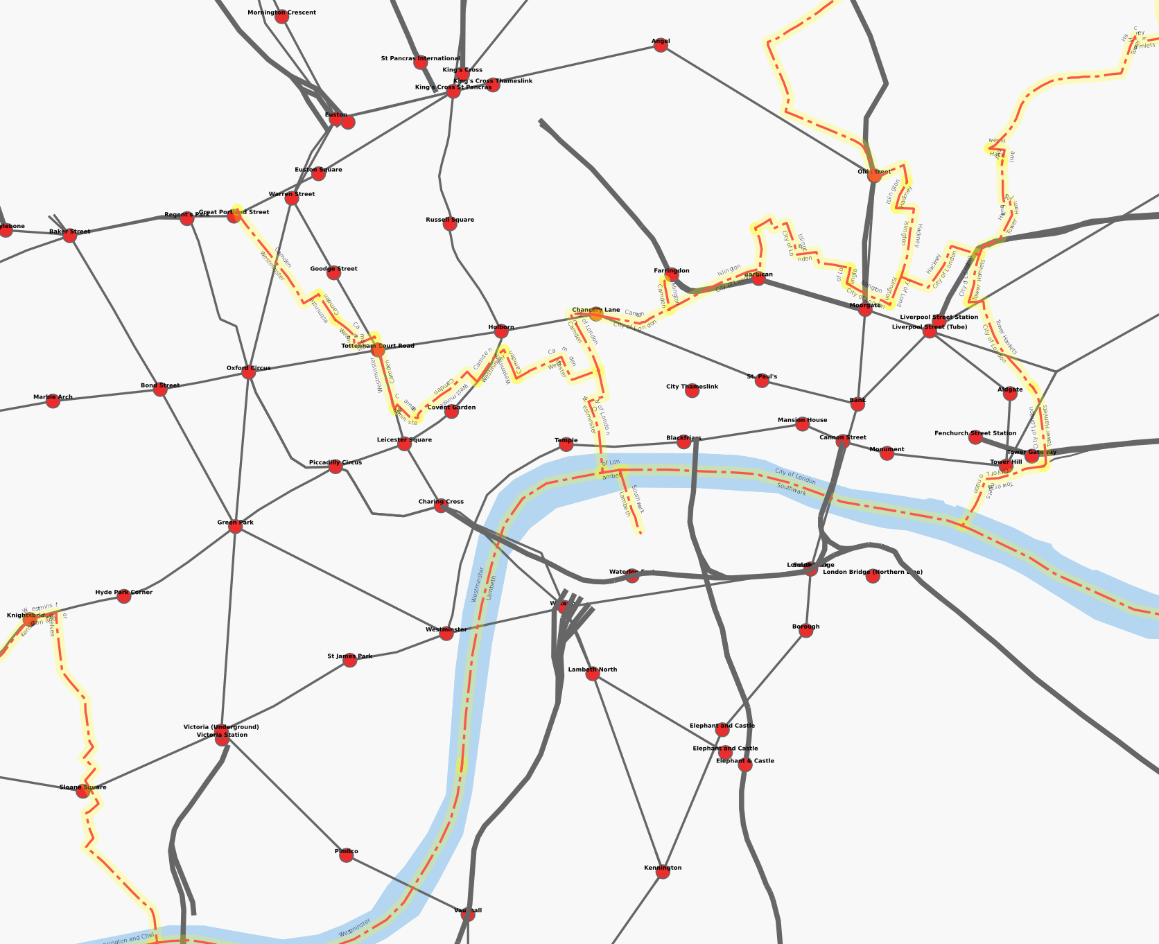
Did good bit more of Belgrave on Wednesday, followed by lots of the West End on Thursday. On Friday I met up with [livejournal.com profile] eldritchreality for a late lunch, then with [livejournal.com profile] riak in the evening at firebug. where we were randomly joined by [livejournal.com profile] djlostbot and [livejournal.com profile] beltainethecat's pet human and a couple of their friends. Alcoholic beverages were consumed.

On Saturday [livejournal.com profile] ioannab and I went to Market Harborough and back via some very odd routes, trying to trace National Cycle Network route 6 and 64. The routes were quite low-traffic but insanely hilly. These should appear on the cycle map sometime later this week. Also, we saw lots of horses.

back from Leicester on Sunday, along the usually freight-only Oakham to Kettering Line. Since it was a class 222 with its evil anti-signal windows, I failed to get a GPS trace. Didn't bring bicycle to London in end, I had too much other luggage. May keep bicycle in Leicester until I have finished mapping it.

Pembury on Sunday was not bad. I sorted the Carcassonne tiles out for the expansions from the base set, and then we (me, [livejournal.com profile] timeplease, [livejournal.com profile] elise, [livejournal.com profile] aquarionical) had an actual game of normal Carcassone for the first time in ages. Tiles are now marked on the back so this problem will not arise again. Still need to sort out the Traders and Builders and King and Scout tiles from each other.

[livejournal.com profile] aquarionical brought along Risk Express, which was indeed less tedious than Risk (in fact, it seems to be a different game that has then had some of the same names for things added to it) but also seemed to even less skill (possibly I am only saying this because I lost).
abigailbrady: (Default)
South East London Mapping Party. tomorrow and Sunday. i won't be able to go due on the Saturday due to work. unsure about sunday. they is friendly bunch. if you are around and interested then pop along either day. tell them i sent you.
abigailbrady: (caerlyr)
Someone has put up a rendering of OpenStreetMap in the UK in Welsh. Some of the data is dodgy, but I expect it will quickly be fixed now there is a practical reason to do this. Looks kind of weird having Welsh names for only some English cities (what is the Welsh for Milton Keynes? Heh. But surely there are Welsh names for Rochester and Manchester?)

update: added Welsh names for Plymouth, Bath, Manchester, Colchester, Lancaster, Salisbury. Corrected Tywyn.
abigailbrady: (leicester)
new years eve. still in leicester. seem to have forgotten to do any socialising.

what i did do was a great deal of mapping on my bicycle:

compare before (left) and after (right):


i'd set myself a target of doing the entirety of leicester east of the railway line. this was not to be, but i'm still quite pleased with what i did : northfields, humberstone, hamilton, netherhall, thurnby lodge, rowlatts hill, north evington, random bits around the city centre, and a good start on crown hills/spinney hills. i hope by year end 2008 it will be finished.

i return to london tomorrow. i shall be in the pembury tavern in the evening.
abigailbrady: (Default)
So today I went to Leicester and then I bought a bicycle. Had a little go on it (the light was going), and it's true, you don't forget. I spoke a bit to the guy who runs the bike shop (it's the little one in the corner of the Town Hall) and he seemed interested in the mapping. The cycle maps they did have done partly by the city council, from 1998, have now all run out and the council are not interested in reprinting, despite demand from customers! Gave him the link to the cycle layer. They could certainly sell printed OSM cycle maps of Leicester. Hopefully not too distant I will have got all the data acquisiton done and then we can see about doing that sort of thing.

OSM

Dec. 10th, 2007 06:01 pm
abigailbrady: (Default)
One of the problems with mapping is how do you know when you've done? This is something OpenStreetMap will need to take seriously, given the present lack of any tags to indicate areas in which there be dragons.

Last month I sent a request for a definitive list of roads which make up the Primary Route Network to the Department for Transport (these are the roads which are signed in green). I recieved this in due course (apparently they'd had to collate it specially), and then sent them an email back asking if I could actually use it to find errors and missing bits in openstreetmap so we could correct them.

Now, I believe this would fall under the "research" exemption for copyright under UK law. Although exceptions for fair use are narrowly drawn compared to the United States (where this would be PD anyway), it nontheless permits "research". And I'm not copying the spreadsheet, I'm using facts from it to send people out to check things on the ground, or to alter a thing that says "highway=primary" to "highway=trunk" or back again.

The DfT pointed me at the OPSI. I asked them. I was told I need to get a Click-Use license for this. I've looked at the terms: this would forbid me to put derived works under a creative commons license, and thus would be entirely useless for OpenStreetMap. I've explained I don't expect them to put the spreadsheet under the PD or a more permissive license, but am just asking for agreement that what I want to do is acceptable in the absence of a license.

The PSI regulations say

The aim of the Regulations is to encourage the re-use of public sector information by removing obstacles that stand in the way of re-use. The main themes are improving transparency, fairness and consistency. In doing so it will help stimulate the development of innovative new information products and services across Europe, so boosting the information industry.

Um, that's us, right?
abigailbrady: (Default)
hmm, maybe today isn't such a good day to go and quietly map the Kensington/Westminster border.
abigailbrady: (Default)
playing around with osmarender, i made a sort of tube map.


it also shows the borough boundaries i've been walking

some missing stations, obviously, and visual artifacts. and in some places tunneled bits are approximated with a straight line. should it try to show major roads (faintly)? how can i indicate the different railway and tube lines (there aren't enough colours).
abigailbrady: (Default)
announcement is here

Saturday 8th and Sunday 9th September. You don't need to have a GPS (they are available for loan) or really any idea what you are doing (it will be explained and newbies can possibly be paired with people who've done it before) beforehand. Plan is to hit the Shoreditch/Wapping area on Saturday, and expand outwards to the vast uncharted wastes of Hackney and Tower Hamlets on the Sunday, depending on how that goes.
abigailbrady: (hackney)
well, that was a lot of effort to go to just to get a new userpic. ;)
abigailbrady: (hackney)
[livejournal.com profile] fluffymark and [livejournal.com profile] antipodienne came round last night and we drank gin and watched dvds and listened to strange music and this was all good.

today i continued my solo circumnavigation of the london borough of hackney. i picked up the segment of the Islington/Hackney border down to old street that i'd missed; then walked along the border down to Sun Street, where it meets the City. The Hackney/Tower Hamlets border was quite tricky in comparison: especially confusing bits were the course in the Shoreditch High Street/Commercial Street/Bethal Green Road, what it does around Haggerston Park, and also at Hackney Wick. But hopefully my deductions aren't too wrong.

the remaining section is the border with Haringey, east from Manor House, then south down the Lee to Hackney Wick again.
abigailbrady: (hackney)
this week i shall be attempting to circumnavigate the london borough of hackney. got most of the border between islington and hackney yesterday: gave up when i got to the bit where the border appears to be the regent's canal as i cannot swim, and it was getting late. going to try for the remaining bit of that and the hackney/tower hamlets border this evening, i think.
abigailbrady: (hackney)
was at state of the map this weekend, (conference for openstreetmap). enjoyed it. tired now. group photo

some things of note

*cartography is serious business. however, with osm, you can do some really freaky shit (i recommend clickying on this even if you don't care about maps in the slightest)
*the multimap founder, slipped in, on bullet points 4 of 5 on a slide towards the end of his talk, that he wanted to see multimap go live using OSM data before the end of the year. presumably just for the isle of wight/cambridge/netherlands/whatever.
*something like 99% of attendees were male. you get a gender skew in free software/content stuff, but this is absurd.
*i must organise a hackney mapping party in august or september.
*xslt is a very scary thing indeed.
*spaghetti junction is hard to render.
*flats don't get any tidier if you just leave them for a weekend
abigailbrady: (Default)
today i walked 18km in Kew Gardens.

my feet hurt.
abigailbrady: (Default)
one of today's letting agents wanted an upfront fee to register with them before. who should i report them to? this has got to be illegal. but news is not entirely bad, as seeing flats tomorrow and tuesday in clapton and manor house respectively.

leicester looks nicer now. presence of river, parks and entire outer and inner ringroads good †. absence of hinckley road and narborough road bad. it's remarkable how much you can do with low-res satellite photos and the out-of-copyright NPE maps.

coming back for the weekend, hope to finish city centre. oh, and meet people...

† not that leicester has an entire outer ringroad, of course.
abigailbrady: (Default)
this weekend i have been mostly mapping SW1 (St James's, Belgravia). going to have to make a return trip to Belgravia to get all the mewses and a few other roads i missed. I discovered that Eaton Square isn't!

pembury this evening for cider&games: beer festival rush had largely finished so we were able to play games without much problem.

work is going well. to bed now..., for an early start tomorrow.
abigailbrady: (Default)
work is good. the area around leicester square appears curiously unmapped so have been doing stuffs there. holborn was better for sandwich shops (or possibly i've just not explored deep enough into the twisty backstreets of soho... we'll see)

i got buffy season 8 #1 today! spoiler ) also i have finished volume 1 of Top Ten finally, and am started on volume 2. this is being quite entertaining, but not especially brilliant.
abigailbrady: (Default)
today's map update. missing: brunel walk, brunel road, victoria crescent, kerswell close, notes as to the one way system, random twiddly bits on russell road and braemar road.

i've not added edgecot grove, which google maps thinks is a through road, as it doesn't seem to exist in any meaningful way (being a very shallow cul-de-sac at one end). that could really catch people out.
abigailbrady: (Default)
i have today two things to report

a) my legs hurt
b) seven sisters is slightly better mapped
abigailbrady: (Default)
GPS device arrived! i spent this afternoon wandering around seven sisters and various other parts of london making GPS trails for openstreetmap (which is like Wikipedia, except for street maps). added a few roads today, will try for a great big wodge of the seven sisters road/west green road triangle tomorrow.

finally started watching Battlestar Galactica. saw the miniseries and the first 2 eps so far.

Profile

abigailbrady: (Default)
Abigail Brady

April 2017

S M T W T F S
      1
234 5678
9101112131415
16171819202122
23242526272829
30      

Syndicate

RSS Atom

Most Popular Tags

Style Credit

Expand Cut Tags

No cut tags
Page generated Jun. 7th, 2025 03:08 pm
Powered by Dreamwidth Studios